![]() MapSnaps
MapSnaps
Your Scenic Guide to the Great Outdoors
|
|
|
|
|
TrailPhotos.com
Your Scenic Guide to the Great Outdoors |
|
|
|||
|
Trails :
TrailPhotos Index
|
TrailPhoto Guides and TrailPhoto Scenes - Hwy. 88 to N. of Yosemite Region Trails QUICK LINKS - REGIONAL DESCRIPTIONS : Hwy. 88 to N. Yosemite Region Overview All Regions: TrailPhoto Guide Overview
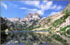
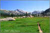
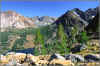
Welcome to the colorful world of TrailPhotos. This is the starting point for exploring the individual TrailPhotos in the Highway 88 to N. Yosemite Region of northern California. Below are thumbnail photos for each of the Hwy. 88 to N. Yosemite Region TrailPhoto Guides and TrailPhoto Scenes. Map numbers show trail locations.
California Location of Hwy. 88 to north of Yosemite Region TrailPhoto Guides and TrailPhoto Scenes _ Hwy. 88 to N. Yosemite TrailPhoto Guides and TrailPhoto Scenes Index Click on Photos below to view larger photo and a brief trail description (trail location is on map above). Thumbnail photos shown in the TrailPhoto Gallery also include links to Extra Large size photos. Difficulty ratings : Easy, Moderate, Strenuous, or Very Strenuous Scenic Value : 1 = Lowest, 10 = Highest Preview or acquire the completed TrailPhoto Guides and TrailPhoto Scenes through the Scribd.com website. TrailPhoto Guides already available on Scribd.com are indicated below. Selected TrailPhoto locations are shown on Google maps for completed Guides (completed Guides say Now Available below. Google maps appear on the jump page after you click photos below). The Photos below are just a taste of the TrailPhotos' content - You can also view a free, complete TrailPhoto Guide Sample at Scribd.com. This sample includes a TrailPhoto Guide to the Eagle Lake Trail in the Lake Tahoe Region, and shows the format and complete content of a TrailPhoto Guide. Other TrailPhoto Guides and a free complete TrailPhoto Scenes sample are also available at: Scribd.com.
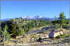
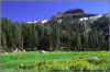
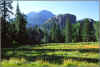
Off Highway 88 Area 1)
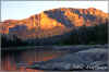
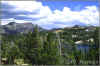
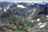
* Difficulty = Moderate ; Scenic value = 6 / 10 * This Guide is still under development 2)
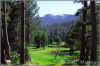
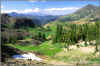
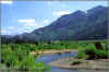
* Difficulty = Moderate ; Scenic value = 7 / 10 * This Guide is still under development 3)
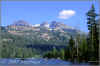
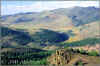
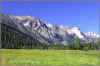
* Difficulty = Easy ; Scenic value = 8 / 10 * This Guide is still under development 4)
* Difficulty = Moderate ; Scenic value = 8 / 10 (Link to Extra Large version of photo) * This Guide is still under development 5)
* Difficulty = Moderate ; Scenic value = 7 / 10 * This Guide is still under development 6)
* Difficulty = Moderate ; Scenic value = 9 / 10 * Trail distance = 7.8 miles ; Preview this Guide at Scribd.com. 7)
* Difficulty = Moderate ; Scenic value = 9 / 10 * This Guide is still under development 8)
* Difficulty = Moderate ; Scenic value = 10 / 10 * This Guide is still under development 9) No * Charity Valley West Trail in Eldorado National Forest Photo * Difficulty = Moderate ; Scenic value = 7 / 10 Yet * This Guide is still under development 10)
* Difficulty = Moderate ; Scenic value = 9 / 10 * This Guide is still under development _ See general overview pages for the Off Hwy. 88 Area _ Off Highway 4 Area 11)
* Difficulty = Strenuous ; Scenic value = 9 / 10 * Trail distance = 10.3 miles ; Preview this Guide at Scribd.com. 12)
* Difficulty = Strenuous ; Scenic value = 9 / 10 (Link to Extra Large version of photo) * This Guide is still under development 13)
* Difficulty = Strenuous ; Scenic value = 7 / 10 * This Guide is still under development _ _ _ 14)
* Difficulty = Strenuous ; Scenic value = 8 / 10 * This Guide is still under development 15)
* Difficulty = Moderate ; Scenic value = 10 / 10 * This Guide is still under development 16)
* Difficulty = Strenuous ; Scenic value = 9 / 10 * This Guide is still under development 17)
* Difficulty = Strenuous ; Scenic value = 8 / 10 * This Guide is still under development _ See general overview pages for the Off Highway 4 Area _ Off Highway 108 Area 18)
* Difficulty = Moderate ; Scenic value = 7 / 10 * This Guide is still under development 19)
* Difficulty = Very Strenuous ; Scenic value = 9 / 10 (Link to Extra Large ver. of photo) * This Guide is still under development 20)
* Difficulty = Very Strenuous ; Scenic value = 9 / 10 (Link to Extra Large ver. of photo) * This Guide is still under development 21)
* Difficulty = Strenuous ; Scenic value = 9 / 10 * Trail distance = 8.5 miles ; Preview this Guide at Scribd.com. 22)
* Difficulty = Easy ; Scenic value = 7 / 10 * This Guide is still under development 23)
* Difficulty = Strenuous ; Scenic value = 9 / 10 (Link to Extra Large version of photo) * This Guide is still under development _ See general overview pages for the Off Highway 108 Area _ Off Highway 395 Area 24)
* Difficulty = Moderate ; Scenic value = 9 / 10 * This Guide is still under development 25)
* Difficulty = Moderate ; Scenic value = 10 / 10 * Trail distance = 7.7 miles ; Preview this Guide at Scribd.com. 26)
* Difficulty = Very Strenuous ; Scenic value = 9 / 10 * This Guide is still under development 27)
* Difficulty = Strenuous ; Scenic value = 10 / 10 (Link to Extra Large version of photo) * This Guide is still under development 28)
* Difficulty = Strenuous ; Scenic value = 10 / 10 (Link to Extra Large version of photo) * This Guide is still under development 29)
* Difficulty = Strenuous ; Scenic value = 10 / 10 (Link to Extra Large version of photo) * This Guide is still under development 30) No * Oneida Lake Trail in Hoover Wilderness Photo * Difficulty = ; Scenic value = Yet * This Guide is still under development _ See general overview pages for the Off Highway 395 Area -
THUMBNAIL PHOTOS FOR OTHER REGIONS : Photos: East Bay TrailPhoto Guide Trails Photos: Lake Tahoe TrailPhoto Guide Trails
TrailPhoto Gallery: Extra Large Photos for Selected TrailPhoto Guide Trails
Home | What's New | FAQ | User Notes | About Us/Contact © 2000-2010 MapSnaps All rights reserved |