|
This Gallery
list links to a selected group of photos from the
TrailPhoto Guides that have extra large sample photos to view.
Many of these are the same photos shown in the main, complete thumbnail photo lists
for the trails included in the TrailPhoto Guides, but at a much larger size. Below are links to
TrailPhoto Gallery photos by
Region.
Click on Photos to view
the Extra Large photo and a brief trail description (these trail locations are
shown on maps
included through the "Photos" links near the bottom of this page).
Difficulty ratings : Easy,
Moderate, Strenuous, or Very Strenuous
Scenic Value : 1 = Lowest,
10 = Highest
Preview or acquire the completed TrailPhoto Guides through
the Scribd.com
website, which provides a service allowing you to view and print out these
files. TrailPhoto
Guides already available on Scribd.com are indicated where Now Available
appears below, others are
coming soon.
The Photos below link to
larger size photos of the Guides'
content -
You
can also view a free, complete TrailPhoto
Guide Sample at Scribd.com. This sample includes a
TrailPhoto Guide to the Eagle Lake Trail in the Lake Tahoe Region, and
shows the format and complete content of a TrailPhoto Guide.
Note:
the numbers next to each of these photos are the
corresponding trail numbers shown in the lists and on the maps for
the TrailPhoto Guides in each Region, as found in the
"Photos" links near the bottom of this page:
-
Lake Tahoe Region TrailPhoto
Gallery
Thumbnail Index
North of Lake Tahoe Area
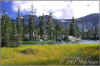
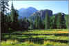
2)
 * PCT S.
of Jackson Meadow Reservoir in Tahoe National Forest
* PCT S.
of Jackson Meadow Reservoir in Tahoe National Forest
*
Difficulty = Strenuous ; Scenic value = 8 / 10
* This
Guide is still under development
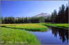
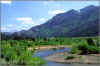
5)
 * Glacier Lake Trail in
Tahoe National Forest
* Glacier Lake Trail in
Tahoe National Forest
*
Difficulty = Moderate ; Scenic value = 9 / 10
* This
Guide is still under development
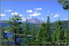
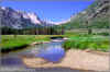
7)
 *
Beyer Lakes Trail in Tahoe National Forest
*
Beyer Lakes Trail in Tahoe National Forest
*
Difficulty = Very Strenuous ; Scenic value = 9 / 10
* This
Guide is still under development
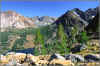
9)
 *
Loch Leven Lakes Trail in Tahoe National Forest
*
Loch Leven Lakes Trail in Tahoe National Forest
*
Difficulty = Moderate ; Scenic value = 8 / 10
* This
Guide is still under development
11)
 * PCT South from I-80 in
Tahoe National Forest
* PCT South from I-80 in
Tahoe National Forest
*
Difficulty = Moderate ; Scenic value = 9 / 10
* This
Guide is still under development
12)
 * Mt. Rose Trail in Mt.
Rose Wilderness (Nevada)
* Mt. Rose Trail in Mt.
Rose Wilderness (Nevada)
*
Difficulty = Strenuous ; Scenic value = 9 / 10
* This
Guide is still under development
_
See general overview
pages for North of Lake Tahoe Area
_
_
West of Lake Tahoe Area
16)
 * Rubicon
Trail in D. L. Bliss State Park
* Rubicon
Trail in D. L. Bliss State Park
*
Difficulty = Easy ; Scenic value = 10 / 10
* This
Guide is still under development
18)
 * Velma
Lakes Trail in Desolation Wilderness
* Velma
Lakes Trail in Desolation Wilderness
*
Difficulty = Very Strenuous ; Scenic value = 10 / 10
* This
Guide is still under development
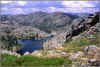
22)
 * Gertrude / Tyler Lakes Trail in Desolation Wilderness
*
Difficulty = Strenuous ; Scenic value = 9 / 10
* This
Guide is still under development
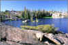
23)
 *
Island / Twin Lakes Trail in Desolation Wilderness
*
Island / Twin Lakes Trail in Desolation Wilderness
*
Difficulty = Strenuous ; Scenic value = 9 / 10
* This
Guide is still under development
_
See general overview
pages for West of Lake Tahoe Area
_
_
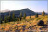
South of Lake Tahoe Area
30)
 * Scotts Lake Trail in
Eldorado National Forest
* Scotts Lake Trail in
Eldorado National Forest
*
Difficulty = Easy ; Scenic value = 8 / 10
* This
Guide is still under development
_
See general overview
pages for South of Lake Tahoe Area
-
Highway 88 to N.
Yosemite Region TrailPhoto Gallery
Thumbnail Index
Off Highway 88 Area
1)
 * Tanglefoot Trail to Shriner Lake Trail
in Mokelumne Wilderness
* Tanglefoot Trail to Shriner Lake Trail
in Mokelumne Wilderness
*
Difficulty = Moderate ; Scenic value = 6 / 10
* This
Guide is still under development
4)
 * Hidden Lake
Loop Trail in Eldorado National Forest
* Hidden Lake
Loop Trail in Eldorado National Forest
*
Difficulty = Moderate ; Scenic value = 8 / 10
* This
Guide is still under development
5)
 * Lake Margaret Trail in Eldorado
National Forest
* Lake Margaret Trail in Eldorado
National Forest
*
Difficulty = Moderate ; Scenic value = 7 / 10
* This
Guide is still under development
_
See general overview
pages for the Off Hwy. 88 Area
_
Off Highway 4 Area
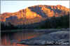
11)
 * Elephant Rock
Lake Trail in Carson-Iceberg Wilderness Now
available
* Elephant Rock
Lake Trail in Carson-Iceberg Wilderness Now
available
*
Difficulty = Strenuous ; Scenic value = 9 / 10
*
Trail distance = 10.3 miles ; Preview this
Guide at Scribd.com.
12)
 * Woodchuck Country Trail in
Mokelumne Wilderness
* Woodchuck Country Trail in
Mokelumne Wilderness
*
Difficulty = Strenuous ; Scenic value = 9 / 10
* This
Guide is still under development
_
See general overview
pages for the Off Highway 4 Area
_
Off Highway 108 Area
19)
 * Relief Reservoir Trail in Emigrant
Wilderness
* Relief Reservoir Trail in Emigrant
Wilderness
*
Difficulty = Very Strenuous ; Scenic value = 9 / 10
* This
Guide is still under development
20)
 * PCT North to Wolf Creek Lake in
Stanislaus / Toiyabe National Forests
* PCT North to Wolf Creek Lake in
Stanislaus / Toiyabe National Forests
*
Difficulty = Very Strenuous ; Scenic value = 9 / 10
* This
Guide is still under development
23)
 * Leavitt
Meadows Trail in Toiyabe National Forest
* Leavitt
Meadows Trail in Toiyabe National Forest
*
Difficulty = Strenuous ; Scenic value = 9 / 10
* This
Guide is still under development
_
See general overview
pages for the Off Highway 108 Area
_
Off Highway 395 Area
24)
 * Buckeye Creek Trail in Toiyabe
National Forest
* Buckeye Creek Trail in Toiyabe
National Forest
*
Difficulty = Moderate ; Scenic value = 9 / 10
* This
Guide is still under development
27)
 * Green Creek to West Lake Trail in
Hoover Wilderness
* Green Creek to West Lake Trail in
Hoover Wilderness
*
Difficulty = Strenuous ; Scenic value = 10 / 10
* This
Guide is still under development
28)
 *
Virginia Lakes Trail in Hoover Wilderness
*
Virginia Lakes Trail in Hoover Wilderness
*
Difficulty = Strenuous ; Scenic value = 10 / 10
* This
Guide is still under development
29)
 * Lundy
Canyon Trail in Hoover Wilderness
* Lundy
Canyon Trail in Hoover Wilderness
*
Difficulty = Strenuous ; Scenic value = 10 / 10
* This
Guide is still under development
_
See general overview
pages for the Off Highway 395 Area
-
East Bay Region TrailPhoto
Gallery Thumbnail Index
These TrailPhoto Gallery pages
are under development -
not yet available.
-
To
see the list of all TrailPhoto Guides and links to the regular
size sample photos and their mapped locations by Region:
Photos:
Lake Tahoe
TrailPhoto Guide Trails
Photos:
Highway 88 to
N. Yosemite
TrailPhoto Guide Trails
Photos:
East Bay TrailPhoto
Guide Trails
|