![]() MapSnaps
MapSnaps
Your Scenic Guide to the Great Outdoors
|
|
|
|
|
TrailPhotos.com
Your Scenic Guide to the Great Outdoors |
|
Trails :
TrailPhotos Index
|
TrailPhoto Guides and TrailPhoto Scenes - Lake Tahoe Region Overview QUICK LINK : Photos: Lake Tahoe TrailPhoto Guide Trails
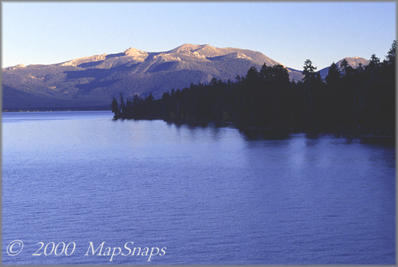
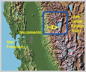
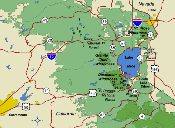
Lake Tahoe from the Rubicon Trail The Lake Tahoe Region is one of the country's premier vacation spots. With abundant natural beauty, outdoor recreation, and visitor accommodations, it is a peerless mountain destination. The Tahoe region offers many diversions. From countless miles of wilderness trails in warmer months to Olympic class ski resorts in the winter, Tahoe has a bit of everything. Tahoe area visitors have a choice of hundreds of miles of trails spread throughout the lake basin, three nearby National Forests, and several Wilderness areas throughout the region. Desolation Wilderness area offers a world of high granite peaks and sparkling lakes, sprinkled with enough forests to cool the warm midsummer days. Granite Chief Wilderness is less well known, but provides the determined visitor a rugged world of stark canyons and ridgetops with sweeping views. The Pacific Crest Trail winds its way through these wilderness areas and above Lake Tahoe on its way from Mexico to Canada. The Tahoe Rim Trail encircles the lake, and portions of that trail are included in the Tahoe TrailPhoto Guides and TrailPhoto Scenes, along with the Mt. Rose Wilderness just north of Lake Tahoe in Nevada. A bit farther away from the Tahoe shores are lesser known trails, somewhat removed from the main visitor areas. Many of these are not too difficult to reach, and offer a chance for greater solitude and new discoveries off the beaten path. Location The Lake Tahoe Region covered here spans the Lake Tahoe Basin recreational area, plus several nearby areas of trails and forests. The maps shown immediately below indicate the general location of trails covered in this section of the TrailPhoto Guides and TrailPhoto Scenes. Each of the highlighted sub-areas within the Tahoe Region links to a separate page on this website, with a more in-depth description of the area and its trails on those pages. Lake Tahoe Region TrailPhotos Terrain Map California Location of Terrain Map The yellow arrow on the Terrain Map above shows the approximate location and viewing direction of the Lake Tahoe photograph displayed in the top center area of this web page. The blue rectangle on the terrain map outlines the approximate coverage area for the Lake Tahoe Region TrailPhoto Guides and TrailPhoto Scenes. -
Lake Tahoe Region TrailPhoto Guides and TrailPhoto Scenes locations (Red arrow shows approximate location and viewing direction of the photo at the top of this page). - Lake Tahoe Region TrailPhoto Guides and TrailPhoto Scenes Descriptions This TrailPhotos.com website has a thumbnail photo index and descriptions of thirty Lake Tahoe Region trails. Descriptions of these TrailPhoto Guides and TrailPhoto Scenes are available along with purchase information from this Photos: All Lake Tahoe TrailPhoto Guide Trails link, for the trails listed below. TrailPhoto Guides and TrailPhoto Scenes for the Tahoe Region are broken out into three main sections, listed below for North, West, and South of Lake Tahoe. Each section of the Lake Tahoe Region has its own web page on TrailPhotos.com, accessible from the links below. The approximate location of these trails is shown on the detailed area map above, matched to the corresponding numbers displayed below. 1) PCT N. of Jackson Meadow Res. 7) Beyer Lakes 2) PCT S. of Jackson Meadow Res. 8) Fordyce Creek 3) Carr Lake to Sawmill Trail 9) Loch Leven Lakes 4) Lindsey Lake 10) PCT North from I-80 5) Glacier Lake 11) PCT South from I-80 6) Carr Lake to Rock Lake 12) Mt. Rose _ 13) Squaw Valley 19) Mt. Tallac 14) Alpine Valley / 5 Lakes 20) Heather / Susie / Aloha Lakes 15) Meeks Creek to Crag Lake 21) Grass Lake 16) Rubicon Trail 22) Gertrude / Tyler Lakes 17) Eagle Lake 23) Island / Twin Lakes 18) Velma Lakes 24) Smith Lakes _ 25) Echo Pass to Cagwin Lake 28) Meiss Meadows Trail 26) Horsetail Falls 29) Big Meadow to Round Lake 27) Echo Pass South 30) Scotts Lake TrailPhoto Guides and TrailPhoto Scenes for this Region: Photos: Lake Tahoe TrailPhoto Guide Trails Related Links The National Forest Service maintains websites with extensive information and park maps. These provide a useful complement to the detailed TrailPhoto Guides and maps on this website, and an official source of this information. The nearest applicable National Forests for the Lake Tahoe Region are (these links will open in a new browser window): Eldorado National Forest - Located around the southwest section of Lake Tahoe. Tahoe National Forest - Located to the north and west of Lake Tahoe. Toiyabe National Forest - Located to the northeast, east and southeast of Tahoe. Other sources of Tahoe area information (these links will open in a new browser window): Tahoe Rim Trail - Trail encircling Lake Tahoe. Lake Tahoe Area Visitors Information - Tahoe area attractions / accommodations. State of California Visitors Information- General information for the Tahoe area. Home | What's New | FAQ | User Notes | About Us/Contact © 2000-2010 MapSnaps All rights reserved |