![]() MapSnaps
MapSnaps
Your Scenic Guide to the Great Outdoors
|
|
|
|
|
TrailPhotos.com
Your Scenic Guide to the Great Outdoors |
|
Trails :
TrailPhotos Index
|
TrailPhoto Guides and TrailPhoto Scenes - South of Lake Tahoe Area QUICK LINKS : Photos: All Lake Tahoe TrailPhoto Guide Trails Overview description page for All Lake Tahoe Region TrailPhotos
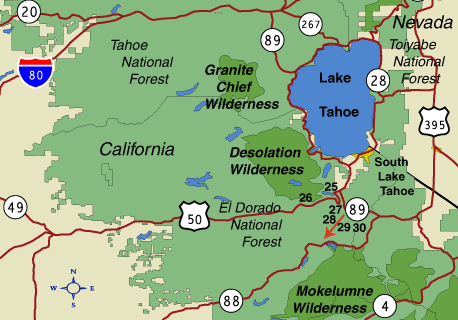
A view to the southwest off of the Big Meadow Trail south of Highway 89 The South of Lake Tahoe Area is another location replete with trails, meadows, and lakes, yet somewhat less rugged than the areas to the west and north of Tahoe. Many large meadows await you in this area, offering open views of surrounding peaks over relatively easier terrain and elevation. Many lakes on these routes seem less alpine in nature, often forming on the meadow floors rather than set within granite rimmed bowls. With this terrain comes a different pace, one that invites lingering at the meadows' edges or on the lakeshores, and less strenuous climbs. The main exception to that in the TrailPhoto Guides and TrailPhoto Scenes included for this area is the section of Pacific Crest Trail south from Highway 50 at Echo Pass, though even that is less taxing than many other portions of the PCT. While some of these trails in the area South of Lake Tahoe are quite popular, others are a little more off the beaten path, allowing a greater chance for seclusion, away from the crowds sometimes found closer to the Lake Tahoe shores. Location These trails are within easy reach of South Lake Tahoe and nearby Meyers, California, within a half hour to an hour's drive of this heart of the Lake Tahoe vacation area. Many of the trails in this area south of Lake Tahoe are easily accessible directly off the section of Highway 89 that continues south and east from Meyers. Others are just off of Highway 50 as it reaches Echo Pass before the descent into the Lake Tahoe basin. Most are quite easy to reach and have parking staging areas right off of these main roads. South of Lake Tahoe TrailPhotos Area California Location of Terrain Map The yellow arrow on the Terrain Map above shows the approximate location and viewing direction of the photograph displayed near the top of this web page. The blue rectangle on the terrain map shows an approximate outline of the South of Lake Tahoe TrailPhotos area.
South of Lake Tahoe Area TrailPhoto Guides and TrailPhoto Scenes locations (Red arrow shows approximate location and viewing direction of the photo shown at the top of this page).
TrailPhoto Guides and TrailPhoto Scenes Descriptions The TrailPhotos.com website has a thumbnail photo index and descriptions of six South of Lake Tahoe Area trails. Descriptions of these TrailPhoto Guides and TrailPhoto Scenes are available along with purchase information at this Photos: All Lake Tahoe TrailPhoto Guide Trails link for the trails listed below. The approximate location of these trails is shown on the detailed area map above, matched to the corresponding numbers displayed below. South of Lake Tahoe Area: 25) Echo Pass to Cagwin Lake 28) Meiss Meadows 26) Horsetail Falls 29) Big Meadow to Round Lake 27) Echo Pass South 30) Scotts Lake
Related Links The National Forest Service maintains websites with extensive information and park maps. These provide a useful complement to the detailed TrailPhoto Guides and maps on this website, and an official source of this information. The applicable National Forests for the South of Lake Tahoe Area are (these links will open in a new browser window): Eldorado National Forest - Located to the south and S.W. of Lake Tahoe. Toiyabe National Forest - Located to the southeast of Lake Tahoe. Other sources of Tahoe area information (will open in a new browser window): Lake Tahoe Area Visitors Information - Tahoe area attractions. State of California Visitors Information- Includes general info. for the S. Tahoe area. Home | What's New | FAQ | User Notes | About Us/Contact © 2000-2010 MapSnaps All rights reserved |