![]() MapSnaps
MapSnaps
Your Scenic Guide to the Great Outdoors
|
|
|
|
|
TrailPhotos.com
Your Scenic Guide to the Great Outdoors |
|
|
|||
|
Trails :
TrailPhotos Index
|
TrailPhoto Guides and TrailPhoto Scenes - Highway 88 to North of Yosemite Region Overview QUICK LINK : Photos: Highway 88 to north of Yosemite TrailPhoto Guide Trails
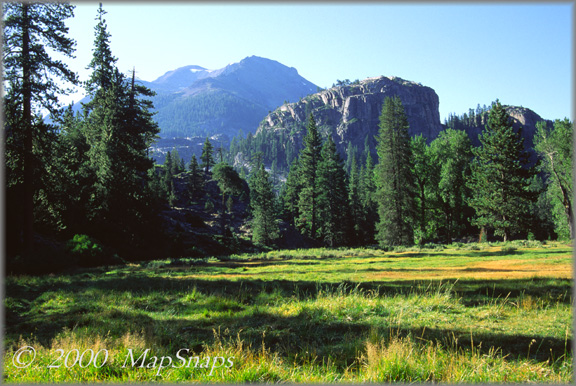
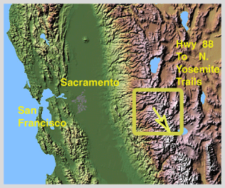
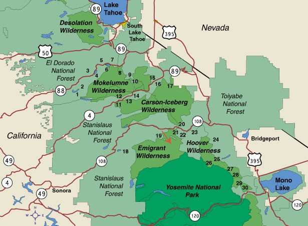
Peaks above Kennedy Meadows' en route to Relief Reservoir, off CA Highway 108 The region stretching south from Highway 88 to the border of the northern reaches of Yosemite National Park in the Sierra Nevada mountains offers a full menu from leisurely Sunday strolls to wicked climbs in the steep but spectacular eastern Sierra. Trails branching off from State Highways 88 and 4 offer the visitor a transition zone of wooded paths and wildflower covered ridges, with a selection of alpine lakes awaiting a cool summer plunge. Included here are the Mokelumne Wilderness, the Carson-Iceberg Wilderness, and the Emigrant Wilderness. Heading further south towards Yosemite, some of the most stunning peaks and meadows covered on this website are located between the town of Bridgeport and Mono Lake in the eastern reaches of the Sierra off U.S. Highway 395 and the Hoover Wilderness. While generally not as well known as the Lake Tahoe Basin to the north, this region frequently offers less crowded getaways and trail excursions for the adventurous. Location The mountains from Highway 88 to the northern part of Yosemite National Park can be reached from the California Central Valley via a number of entry points. California Highways 88, 4, and 108 cross the range into the eastern Sierra and on to Nevada. Highway 120 bisects Yosemite from east to west, though the trails currently covered on this website are all located to the north of 120. US Highway 395 stretches north-south on the eastern side of the Sierra crest, connecting these other routes that cross the range from East to West. The maps shown immediately below indicate the general location of trails covered in this section of the TrailPhoto Guides and TrailPhoto Scenes. Each of these highway route areas links to a separate page on this website, with a more in-depth description of the area and its trails on those pages. The yellow arrow on the Terrain Map above shows the approximate location and viewing direction of the photo displayed near the top of this web page. The olive rectangle on the terrain map outlines the approx. coverage area for the Highway 88 to north of Yosemite Region TrailPhoto Guides and TrailPhoto Scenes. - Highway 88 to north of Yosemite TrailPhoto Guides and TrailPhoto Scenes locations (Red arrow shows approximate location and direction of the photo at the top of this page for the Highway 88 to north of Yosemite Region). - Highway 88 to north Yosemite Region TrailPhoto Guides and TrailPhoto Scenes Descriptions This TrailPhotos.com website has a thumbnail photo index and descriptions of thirty trails in the Highway 88 to north Yosemite National Park border region. Descriptions of these TrailPhoto Guides and TrailPhoto Scenes are available along with purchase information from this Photos: Highway 88 to N. Yosemite TrailPhoto Guide Trails link, for the trails listed below. This Region's TrailPhoto Guides and TrailPhoto Scenes are broken out into four sections along each of the following highway corridors. More information is available for each area listed below by clicking on the section name. The approximate location of these trails is shown on the detailed area map above, matched to the corresponding numbers displayed below: 1) Tanglefoot Trail to Shiner Lake 6) Caples Lake to Emigrant Lake 2) Devil's Lake 7) PCT North to Showers Lake 3) Shealor Lake 8) Roundtop to 4th of July Lake 4) Hidden Lake Loop 9) Charity Valley West 5) Lake Margaret 10) PCT North from Blue Lakes _ 11) Alpine Lake / Elephant Rock Lake 15) PCT North to Raymond Valley 12) Woodchuck Country 16) PCT South to Nobel Canyon 13) Mosquito Lake to Bull Run Lake 17) High Trail 14) Pacific Valley to Bull Run Peak _ 18) Dodge Ridge to Bear Lake 21) PCT South to Leavitt Lake 19) Relief Reservoir Trail 22) Sardine Falls Trail 20) PCT North to Wolf Creek Lake 23) Leavitt Meadows Trail _ 24) Buckeye Creek 28) Virginia Lakes 25) Twin Lakes to Barney Lake 29) Lundy Canyon Trail 26) Barney Lake to Kerrick Meadow 30) Oneida Lake 27) Green Creek to West Lake TrailPhoto Guides and TrailPhoto Scenes for this Region: Photos: Highway 88 to north of Yosemite TrailPhoto Guide Trails Related Links The National Forest Service maintains websites with extensive information and park maps. These provide an official and useful complement to the detailed TrailPhoto Guides and maps on this website. The applicable National Forests for the Highway 88 to North Yosemite National Park Area are (these links will open in a new browser window): Eldorado National Forest - Located around the Highway 88 area. Stanislaus National Forest - Located around the Highway 4 and Highway 108 areas. Toiyabe National Forest - Located around the Highway 108 and Highway 395 areas. Other sources of information for this area (these links open in a new browser window): Yosemite National Park Information - Related to trails in the Highway 395 area. State of California Visitors Information - Includes general info for these areas off Hwy. 88 / Yosemite. Home | What's New | FAQ | User Notes | About Us/Contact © 2000-2010 MapSnaps All rights reserved |