![]() MapSnaps
MapSnaps
Your Scenic Guide to the Great Outdoors
|
|
|
|
|
TrailPhotos.com
Your Scenic Guide to the Great Outdoors |
|
|
|||
|
Trails :
TrailPhotos Index
|
TrailPhoto Guides and TrailPhoto Scenes - Off Hwy. 395 Area QUICK LINKS : Photos: All Highway 88 to N. Yosemite TrailPhoto Guide Trails Overview description page - All Hwy. 88 to N. Yosemite Region TrailPhotos
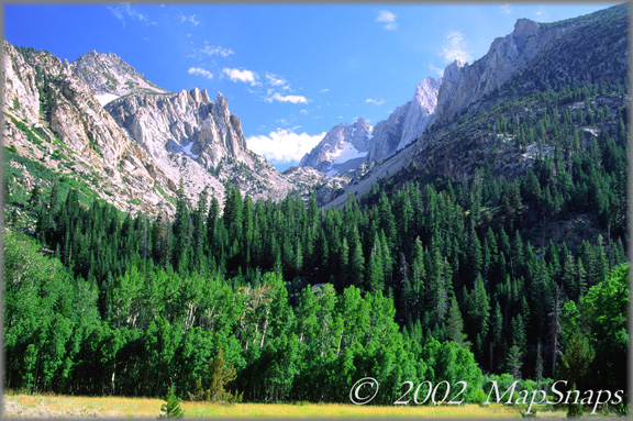
Meadow and peaks just off the trail through the valley to Barney Lake U.S. Highway 395 is one of the most awe inspiring drives in the United States. Weaving south from Lake Tahoe, it winds through the drier eastern Sierra country over the crest and along the valley floor to the east of the Sierra Nevada range. While much of the immediate terrain is semi-arid and lacking trees, the views to the high Sierra peaks are unobscured and all consuming. Rising from the sagebrush and rolling foothills, the Sierra Crest presents the classic weather eroded massifs and spires of the backbone ridge of the western coastal states. Periodically, a salmon hued sunrise or an afternoon flash thunderstorm burst will intensify the drama of this already powerful terrain. Or you round the bend and begin a long cruise on the 395 downgrade with bright blue Mono Lake floating below like an inverted azure cloud. All that, then it gets better. Numerous roads pierce the eastern Sierra spine from U.S. 395, heading west into the mountains until slammed to a halt by the high peaks themselves. At these road ends are typically alpine lakes, camp grounds, and staging areas for journeys into the high country. Each of these trailhead roads have their own unique environment and character, making all of them worth exploration. It is here that the majority of the TrailPhoto Guides and TrailPhoto Scenes in this Off Hwy. U.S. 395 section originate, and it is fair to say that they are among the most scenic and grandiose of all the TrailPhotos. These trails can be challenging, given their high elevation and periodic steepness. The rewards are plentiful though: the exposed and serrated rock cliffs are enormous and majestic. Trails are peppered with an appealing mix of clear alpine lakes, green meadows blanketed with wildflowers, and lingering glaciers clinging to the mountain crevices. Some of these trails are wildly popular with summer vacationers, yet by setting out early in the morning or later in the afternoon, one can find more solitude if desired. In the Highway 395 region, the TrailPhotos cover the area from below state Highway 108 south to Mono Lake. Most of the TrailPhotos in this section reach into the Hoover Wilderness, a mountain paradise, and the inspiration for many a calendar page and coffee table book. These trails lie primarily within the Toiyabe and Inyo National Forest regions, and one of these TrailPhoto Guides briefly enters Yosemite National Park from the Hoover Wilderness. The eastern Sierra lands of parks, wilderness, and trails stretch a few hundred miles further south of Mono Lake, with equally spectacular landscape and outdoor opportunities. At this time, however, the TrailPhoto Guides and TrailPhoto Scenes are available only for the area north of Highway 120. Location The TrailPhoto trails accessed from U.S. Highway 395 typically require a 10-20 mile drive up an access road into the heart of the mountains to reach the trailheads. These are normally paved, though not in all cases, and are typically scenic drives themselves. Most have ample parking at or near the trailheads, with the exception of peak times on very busy summer weekends. The maps below give an overview of these trails' general location. Off Highway 395 TrailPhotos Area California Location of Terrain Map The yellow arrow on the Terrain Map above shows the approximate location and viewing direction of the photograph displayed in the top center area of this web page. The olive colored rectangle on the terrain map outlines the general coverage area for the Off Highway 395 TrailPhotos.
Off Highway 395 TrailPhoto Guides and TrailPhoto Scenes locations (Red arrow shows approximate location and viewing direction of the photo shown at the top of this page).
TrailPhoto Guides and TrailPhoto Scenes Descriptions The TrailPhotos.com website has a thumbnail photo index and descriptions of seven Off Highway 395 Area trails. Descriptions of these TrailPhoto Guides and TrailPhoto Scenes are available along with purchase information at this Photos: All Highway 88 to N. Yosemite TrailPhoto Guide Trails link for the trails listed below. The approximate location of these trails is shown on the detailed area map above, matched to the corresponding numbers displayed below. Off Highway 395 Area 24) Buckeye Creek 28) Virginia Lakes 25) Twin Lakes to Barney Lake 29) Lundy Canyon 26) Barney Lake to Kerrick Meadow 30) Oneida Lake 27) Green Creek to West Lake
Related Links The National Forest Service maintains websites with extensive information and park maps. These provide an official and useful complement to the detailed TrailPhoto Guides and maps on this website. The applicable National Forests and Wilderness Area for the Off Highway 395 Area are (these links will open in a new browser window): Inyo National Forest - In the southern part of this Highway 395 area. Toiyabe National Forest - In the northern part of this Highway 395 area. Hoover Wilderness - West of the Highway 395 area, in the higher peaks. Other sources of Highway 395 area information (Opens in a new window): State of California Visitors' Information - General info. including the Highway 395 area Home | What's New | FAQ | User Notes | About Us/Contact © 2000-2010 MapSnaps All rights reserved |