![]() MapSnaps
MapSnaps
Your Scenic Guide to the Great Outdoors
|
|
|
|
|
TrailPhotos.com
Your Scenic Guide to the Great Outdoors |
|
|
|||
|
Trails :
TrailPhotos Index
|
TrailPhoto Guides and TrailPhoto Scenes - East Bay Region Overview QUICK LINK : Photos: East Bay TrailPhoto Guide Trails
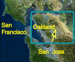
Rumpled, golden green hills roll to infinity at Mission Peak Regional Preserve The East Bay Region of the San Francisco Bay Area contains many parks, reservoirs, and wilderness expanses with hundreds of miles of trails. East Bay open spaces are blanketed with heavier woods and cooler climes in the west side hills just above Berkeley and Oakland down through Fremont. Open expanses of rolling hills and oak trees dominate the terrain east of the Berkeley/Oakland hills. Location The East Bay Region of the TrailPhoto Guides and TrailPhoto Scenes extends throughout the entire counties of Alameda and Contra Costa, to the east of San Francisco. The maps shown below indicate the general location of trails covered in this section of TrailPhotos. Each of the highlighted park districts and other park areas shown on the detailed map that follows have links to further information on websites provided by their land management organizations.
-
East Bay Region TrailPhoto Guides and TrailPhoto Scenes locations (Arrows on these maps show approximate location and viewing direction of the photo at the top of this page, in the East Bay Regional Park District). - East Bay Region TrailPhoto Guides and TrailPhoto Scenes Descriptions This TrailPhotos website has a thumbnail photo index and descriptions of thirty-one East Bay Region trails. Descriptions of these TrailPhoto Guides and TrailPhoto Scenes are available along with purchase information from this Photos: East Bay TrailPhoto Guide Trails link for the trails listed below. These include descriptions of fifteen of the EBRPD park areas, three EBMUD areas, Mt. Diablo State Park, and two open space areas maintained by city departments. This does not encompass all the main parks of the East Bay, but does cover several areas that have major trail mileage. The East Bay Regional Park District (EBRPD) is the primary open space agency in this area, though Mt. Diablo State Park is the single most dominant park. There are other trails as well, in the watershed lands of the East Bay Municipal Utility District (EBMUD), Shell Ridge open space in Walnut Creek, and Lime Ridge open space in Walnut Creek and Concord. Miles of open country and forest covered trails await the adventurous. These lands are open to all, and most can be visited free of charge. There is a small entrance fee at Mt. Diablo State Park parking areas, and the EBMUD lands require that a trail permit be obtained ahead of time, also for a minor fee. A few of the EBRPD lands have parking fees, though many trailheads do not. East Bay Region open space descriptions and external links to the parks and trails covered in the East Bay TrailPhoto Guides and TrailPhoto Scenes are shown below, matched to the the corresponding numbers on map above: Note: Park links underlined below connect to information about them at external websites, in a new browser window. East Bay Regional Park District Area IN ALAMEDA COUNTY : Wildcat Canyon Park Dry Creek Pioneer / Garin Parks 1) Boas - San Pablo Ridge Trail 6) High Ridge Trail Tilden Park 7) Vista Peak Loop Trail 2) Quarry - Seaview Trail Mission Peak Preserve Sibley Volcanic Preserve 8) Hidden Valley - Eagle Trail 3) Round Top Loop - Volcanic Trail Sunol / Ohlone Wilderness Roberts / Redwood Park 9) Indian Joe - Grande Vista Trail 4) Graham - West Ridge Trail 10) McCorkle Trail Anthony Chabot Park Pleasanton Ridge Park 5) Grass Valley - Goldenrod Trail 11) Thermalito - Ridgeline Trail _ IN CONTRA COSTA COUNTY : Las Trampas / Little Hills Wilderness Black Diamond Mines Preserve 12) Elderberry - Upper Ridge Trail 17) Clayton - Black Diamond Trail 13) Las Trampas Ridge Trail 18) Stewartville - Ridge Trail Briones Park Round Valley Preserve 14) Lafayette Ridge Trail 19) Miwok Trail 15) Briones Crest Trail Morgan Territory Preserve 16) Old Briones Road Trail 20) Blue Oak - Valley View Trail Castle Rock /Diablo Foothills Park 21) Highland Ridge Trail See Trail # 29 - Also joins with Shell Ridge Park _ Mt. Diablo State Park Area (In Contra Costa County) 22) Finley Road Trail 24) Black Hawk Ridge Trail 23) BBQ Terrace Road 25) Diablo Falls Trail _ East Bay Municipal Utility District Area (In Alameda and Contra Costa Counties) 26) Ramage Peak Trail 28) Briones Reservoir Trail 27) San Leandro Reservoir Trail _ Other East Bay Park Areas (In Contra Costa County) 29) Costanoan Trail 30) Kovar - Ridge Top Trail 31) Quarry Trail TrailPhoto Guides and TrailPhoto Scenes for this Region: Photos: East Bay TrailPhoto Guide Trails Some great external links for exploring East Bay natural areas and trails: Bay Nature The premier website & magazine for San Francisco Bay Area natural areas Transit & Trails A great website allowing you to plan your trips to Bay Area trails via public transit Home | What's New | FAQ | User Notes | About Us/Contact © 2000-2010 MapSnaps All rights reserved |